Tomorrow's mobility: sustainable traffic concepts, low-emission mobility and climate protection are setting the agenda for the future. How can traffic forecasts be used to enable a more efficient flow of mobility in metropolitan areas?
In mid-March, the Federal Environment Agency presented its annual report on emissions data for the Federal Republic of Germany. The result: Germany has achieved its climate protection targets for 2020. Emissions fell by 40.8% compared to 1990. First of all, a success! However, this is dampened by the fact that about one third of the savings can be linked to the current covid pandemic.
That doesn't really sound surprising: production has been downsized in many areas, people are flying less on vacation, and many are also not commuting to work in their cars as they are working from home. Data also makes this quantitatively visible and illustrative. For example, the Google Mobility Report for February and March shows that visits to leisure areas, i.e. cafés, museums, cinemas, etc., have fallen by around 32% in Germany compared to the same time last year, while visits to workplaces have dropped by 24%. At the same time, visits to parks increased by 12% (see Google Mobility Report, March 16, 2021).
And public transport use also declined: stations and stops were visited 32% less frequently than in the same period last year. It's hard to miss: Mobility is a central adjusting screw for achieving climate protection and sustainability goals.
The CO2 savings in 2020 are significant. Unfortunately, these savings cannot be attributed solely to an optimization of mobility offerings, but to the abandonment of mobility altogether. In this context, sustainable and low-emission mobility is a key issue, especially in metropolitan areas. In major cities, for example, the volume of traffic will triple by 2050. This means that there is still a lot that needs to be done. Accordingly, the issue is also reflected in the election programs of almost all parties running in the super election year 2021.
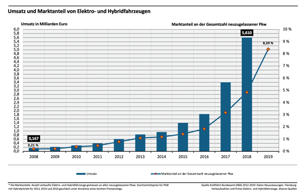
On the other hand, more and more initiatives and approaches are also emerging to achieve the sustainability goals. In addition to stepping up research into synthetic fuels, current solutions include the expansion of electromobility. The proportion of electric and hybrid vehicles has increased significantly in recent years:
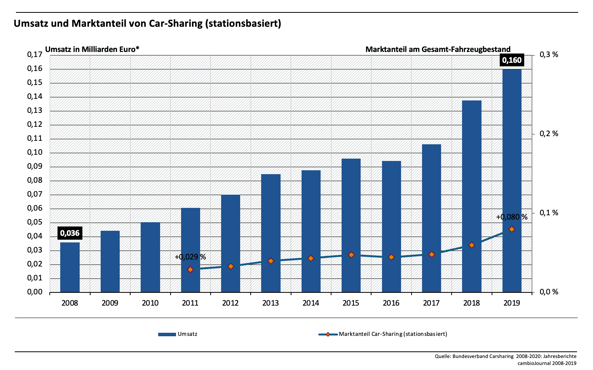
Car-sharing is also experiencing strong growth due to the increasingly desired flexibility in large cities.
On the other hand, solutions can also be found in further networking data sources in the course of digitization, which may lead to existing mobility offerings being optimized and made more efficient.
Ultimately, the efficiency of mobility comes not only from new technologies, but also from the efficient use and capacity utilization of existing modes of transport and the coordination of supply, demand and sustainability. Certain questions play an important role here:
Where is a need for mobility? Where are more services required? Where does a city's mobility system reach its load limit? Where would be the ideal location for a public charging station for electric cars? Where would be a suitable parking lot for a car-sharing provider? What factors should guide a public transport network and its frequency?
These questions can all be answered by using location intelligence
Location intelligence comes into play to answer these questions: We can use the increasing networking of mobility data to generate traffic forecasts in metropolitan areas and thus make them useful for decision-making processes. This enables cities and municipalities to bring about a more efficient flow of mobility, be it through car sharing or a more effective public transport. In this way, cities and municipalities can move a step closer to their sustainability goals.
This is exactly what we have already successfully realized with Siemens AG:
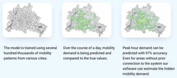
Geospin has developed a forecasting model that is able to determine the demand for mobility services in cities for each individual mode of transport. And it does so both on a geographical and temporal level (depending on the time of day):
But what added value does this give me if no data or empirical values are yet available for a specific mode of transport in a specific area?
Thanks to our strong machine learning techniques, our forecasting model is also able to be applied to areas where a mode of transport has not yet been offered.
The advantages are obvious:
Geospin's location intelligence may help existing public transport networks and car-sharing fleets achieve better and more efficient utilization. The analyses may also be used to prepare for incidents in a much more targeted and rapid manner. Developments and decisions can thus be substantiated and additionally justified with a solid data basis.
Based on the analyses, entire new mobility concepts may also be developed that are perfectly geared to local needs, such as demand-responsive transport.
And does that work? We'll let the experts speak for themselves:
„Geospin provides strong technical expertise and powerful algorithms for various mobility services. The models proved to be particularly useful for transferring knowledge between different cities. That way we could forecast mobility demand for areas where we currently do not have any mobility data.“
Dr. Christian Schwingenschlögl, Head Mobility Data Analytics, Siemens Mobility GmbH.
This transferability has proven to be a benefit in many ways. For example, data on developments in one city serve as support for decisions in other cities that are about to develop and make an important decision. One city thus benefits indirectly from the experience of another.
Similar processes are also conceivable for rural regions, which can thus also make a decisive contribution to the quality of life through more efficient and demand-oriented mobility.
Click here for more information on our case study with Siemens AG.
If we have a more sustainable and climate-friendly future in mind, mobility is a lever we definitely need to tackle. Digitalization offers enormous synergy potential for planning and decision-making processes. And this is precisely where the benefits of networking and location intelligence can come into play. Geospin is an expert here.
Innovations are already there; we just have to use them.
Would you like to get an overview of where charging stations, parking spaces, gas stations, public transport stops or car sharing stations are located? Or would you like to rely on an objective analysis that identifies the most attractive locations for new charging stations? Then take a look at our Location Intelligence Portal.