"Where can I get a crispy Brezel? Show me the quickest way to get my after-work beer? Where is the local townhall or the gym?"
You know these extremely important questions of survival that most of us ask ourselves day by day and that therefore make up a big part of our daily lives and decisions. Ever since the breakthrough of digital maps, it has never been easier to get quick answers to these kinds of questions: Just open your browser, type in what you are looking for and make a decision on the basis of what Google Maps shows you.
So first of all, a big toast to all the benefits that this has brought to us!
However, is this the Location Intelligence everybody is talking about recently?
To answer this question it helps to draw a small analogy: If you compare location intelligence to human intelligence, these everyday approaches mentioned above would only activate a minimal percentage of an average brain’s capacity. It would therefore remain below its potential. A central aspect of human intelligence though lies in the fact that “it reflects a broader and deeper capability for comprehending our surroundings—catching on, making sense of things, or figuring out what to do.”[1]
In analogy to that, location intelligence refers to a way broader access to geodata and opens a huge field of possible applications: Location Intelligence comprehends the complexity of all kinds of location and spatial data. It brings them together and by relating the aforementioned data to one another it identifies the relevant factors of influence or key parameters.
Location Intelligence – processing and analyzing an immense spectrum of data
This data consists of much more than one could intuitively guess: we work with sociological data, based on Zensus datasets (e.g., how many families live in a certain sector, how old is the average inhabitant of a quarter), security data (e.g., how high is the criminality rate), technical data (e.g., broadband availability) and far more. A growing number of communities provide Open Data sources on different levels (e.g., the German state North Rhine-Westphalia on https://open.nrw/). Geospin unites all these data sources and creates a resilient and powerful synthesis. Germany in general shows remarkably high potential in the application of location intelligence (3rd rang in the Geospatial Readiness Index 2019 [2] ).
How do I find my way through this data jungle?
For an average human user and oftentimes even for a domain expert it is difficult to take the amount of data into account and to draw effective conclusions: What data is relevant for what I am looking for? How do I combine the different data sources? How do I weight them, e.g., which data is more relevant for my objectives?
Data-driven decision-making is one of the most promising trends for the next decades.
And therein lies the expertise of remarkable LIA, Geospin’s Location Intelligence Assistant.
What does LIA offer that Google Maps doesn't?
Let’s go back again to our analogy with human intelligence. LIA is Geospin’s artificial intelligence, capable to overview, combine and weight the variety of different layers of data. She can assist you in making complex decisions based on solid facts. She helps you to navigate yourself through the data jungle.
How does she do that? Artificial Intelligence. More precisely, by applying Machine Learning algorithms that simulate decision-making processes. She is trained by previous decisions and their results. In its calculations she takes into account a number of analyses a human brain can only dream of.
Let us give you a short example:
A public utility company aims to promote sustainability in the city by building electric car charging stations. LIA analyzes historical data of charging stations and learns what makes a charging station an effective one. She finds out the most important features for an ideal location. LIA identifies and visualizes the most promising locations for these charging stations in our Geospin Portal:
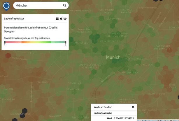
Find out more about LIA's Analysis for Charging Infrastructure.
Conclusion
Location Intelligence is far more than looking up distances on Google Maps. Location Intelligence can be considered the analogy for human’s logic intelligence scaled up on an enormous capacity. It hence meets the complexity and variety of spatial data. So, our Location Intelligence Assistant can definitely help to tell you the best and closest place to get a Döner Kebap like Google Maps does.
However, would you really use your Dolby Surround Hi-fi system to listen to Nokia's ancient monophonic ringtones?

[2] https://issuu.com/geospatialworld/docs/20190329-geobuiz-report-2019-freeve, p. 42-43.


